The Earth is layered. The layer we play and dance on, the crust, is the outermost layer. Beneath the crust is the honey-like mantle and under that is the liquid outer-core. The final ‘layer,’ the core, is a solid sphere. From where you’re standing/playing/dancing to the center of the core is a bit under 4,000 miles (to give a sense of size, the deepest hole humans have ever drilled is only 7.5 miles deep). Of all the layers, the mantle is the most massive, comprising more than 80% of the entire mass of the planet.
The layering of the Earth that is most relevant to earthquakes is called the lithosphere, of which consists of the crust and the upper mantle. The lithosphere is broken up into tectonic plates. There about 12 major plates on our planet. Earthquakes like the ones that rocked Haiti and Chile occur at the boundaries of these plates – they are the consequence of adjacent plates moving relative to one another, and they often release astronomical amounts of stress in the form of quakes that can, as we saw in the news, devastate entire nations. Plate boundaries take on three main forms: they are either spreading apart (also called a divergent boundary), sliding past each other (also known as a transform fault boundary, like the San Andreas), or they’re colliding into one another (this is called a convergent boundary). Collectively, all this plates-smacking-into-plates business is called plate tectonics, and its discovery is long and storied. Let’s take a look:
Alfred Wegener – a German geoscientist with a stalwart will who died on his way back from a rescue operation to bring supplies to a remote research station in the middle of the Greenland icecap – correctly noted how well the coastlines of Africa and South America appear to fit together like two pieces of a puzzle. While he wasn’t the first person to notice this peculiarity, Wegener was the first to use rock and fossil evidence to prove without a doubt that the Americas were once connected to Africa and Europe. Ultimately this led Wegener to propose his now-famous and now-confirmed theory of continental drift, which basically states that the continents of the world are in motion relative to one another rather than being static. Wegener’s theory meant that Charles Schuchert, a 19th and 20th century paleontologist who said that “the striking similarity of the coastlines of Africa and Brazil must have been made by Satan,” could finally rest easy knowing that the Desolate One probably had nothing to do with the geographic layout of the Earth’s continents.
While Wegener presented good evidence to show that the Earth’s continents are in motion, his theory was missing one key part: a mechanism. Sure you found two of the same fossil on two separate continents, proving that they were once connected, but how, Dr. Wegener, do the continents move? Wegener had no good answer for this, and it wasn’t until World War II that evidence for a mechanism for continental drift would begin accumulating.
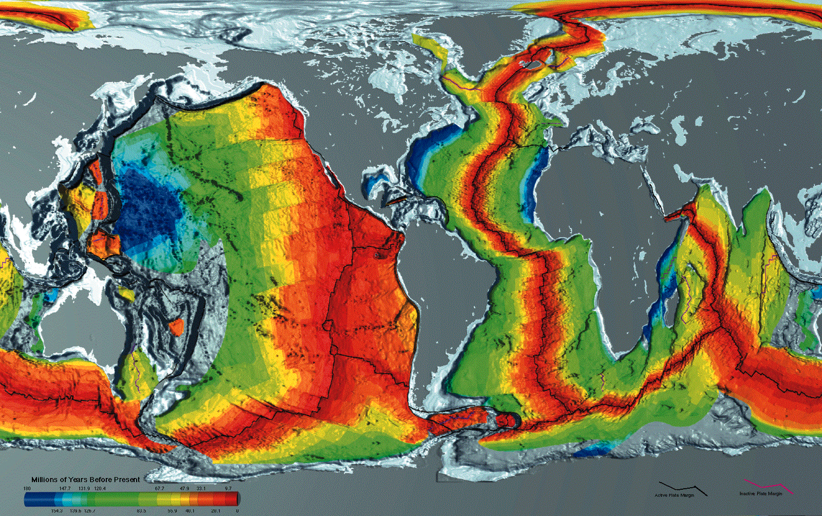
Enter Professor Harry Hammond Hess, who was a naval officer during World War II who performed echo-sounding surveys of the Pacific Ocean’s seafloor while his warship was traveling to and from various battles and skirmishes. These echo surveys, which provided an elevation map of the Pacific’s seafloor, gave Hess the data he needed to come up with his essential theory of seafloor spreading which, simply put, is exactly what it sounds like: mantle magma shoots up from underneath the crust (continental or oceanic), forming what’s called a spreading center (or a divergent tectonic plate boundary, aka a mid-ocean ridge system) that pushes the crust out and away and into other plates, which in turn can form new plate boundaries which can become ridden with stress. In Photo 1, these spreading centers are found in the red zones of the map (red = new ‘hot’ crust, while the ‘colder’ colors like green and blue = older crust that’s being pushed away by the red). It's this pushing and prodding of the plates against other plates that causes their movement which, in turn, causes earthquakes like the ones in Haiti, Chile and in any other area on the planet that rests at the boundary between two or three (but never four) different tectonic plates. Note in Photo 2 how both Haiti and Chile are found on plate boundaries. Coincidence? Haha, yeah, sure.


No comments:
Post a Comment